Revolution comes to New Haven and militia from surrounding towns muster into action
Citizens from Woodbridge and Bethany defend against Tryon's Invasion of New Haven on July 5th 1779
Taking place 245 years ago today, the Invasion of New Haven was part of a series of British raids in the summer of 1779 along the Connecticut coast during the American Revolutionary War. Led by Major General William Tryon, a force of about 2,600 British troops landed to the west and east of New Haven Harbor on July 5, aiming to disrupt American supplies and weaken morale. The British troops quickly seized control of the town, facing resistance from local militia and Yale students. Despite orders to burn the town, the destruction was mostly limited to military stores and public buildings and barns filled with grain. By the time the British withdrew, over 1,000 militia had mustered from the surrounding towns — including Woodbridge and Bethany.
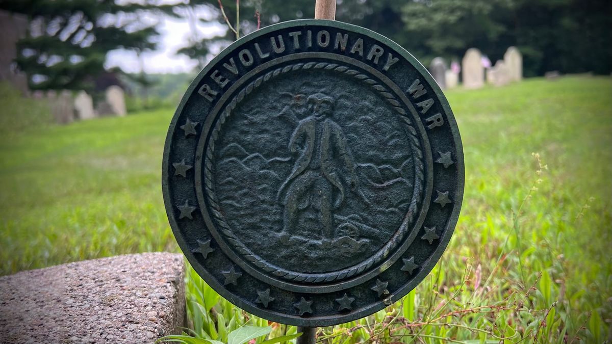
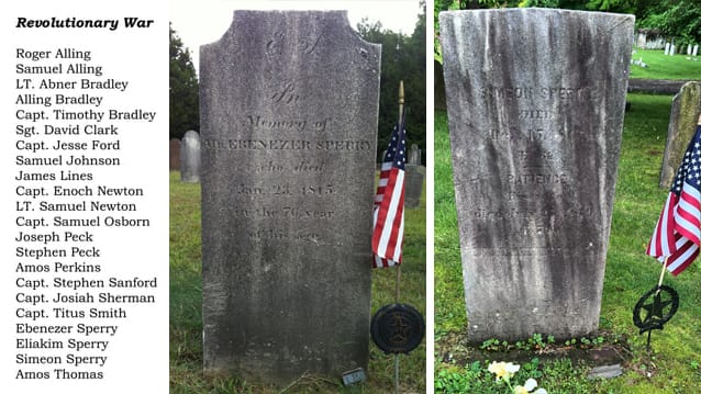
Let's take a dive into the historical record to look for the people of our community who took part in this and other battles of the Revolution. At the Eastside Burying Ground on Pease Road, the remains of twenty-two Revolutionary War Patriots are interred. The Find-A-Grave website includes all of these men, as well as others named in the Sons of the American Revolution's 'Patriots of New Haven County' listing for the General David Humprey's Branch by Ethan A. Stewart Sr., in a collection titled 'Revolutionary War Patriots of Woodbridge & Bethany.' And here are the Eastside's twenty-two entries, as listed on the signpost constructed at Eastside by Jason Luciani for his Eaglescout Project with troop 907:
What else do we know about the actions of these men during the Invasion of New Haven? According to a passage published in 'A History of Woodbridge' prepared by the Bicentennial Commission in 1976, Ebenezer Sperry's wife, Bathsheba Sperry (1749-1858) “standing in the doorway of her house, watched a company of red-coats in the distance and later saw a group from Bethany hurrying down the Litchfield Road.”
Where in Woodbridge was this house located? The couple's grandson, Calvin Sperry (1806-1871), inherited the family's property in the area between present-day Bradley Road and Bond Road, bordered by Amity Road to the west and Litchfield Turnpike to the east. In fact, Bond Road derives its name from Calvin's granddaughter Clara Sperry (1861-1939), a daughter of his son Elizur LeRoy Sperry (1831-1901), who married Charles Alonzo Bond (1857-1943) in 1883.
In an obituary for Calvin Sperry's daughter, Almira Sperry Baldwin Turner (1837-1911), we find further details:
"Ebenezer Sperry, was a native of Woodbridge, born July 27, 1773, on what is known as the Sperry farm, and is still owned by the Sperry family. The house standing thereon was built when he was a child of five years. He wedded Mary Newton Booth, also a native of Woodbridge and a daughter of Walter and Mary (Newton) Booth. He died Oct. 26, 1850, and she departed this life Feb. 2, 1865, at the age of eighty-two years. They had two children, of whom Calvin, the father of our subject, was the youngest.
Calvin Sperry was born on the old homestead Dec. 11, 1807, and there spent his entire life engaged in agricultural pursuits. In addition to general farming, he was also engaged in the milk business for a time, and in his undertakings met with fair success. He was a staunch supporter of the Republican party and its principles, and was a consistent member of the Congregational Church of Woodbridge. After an honorable and useful career he died May 28, 1871, in his sixty-fourth year."
But which house, built when Ebenezer Sperry Jr. is “a child of five” (in other words, circa 1778) and from the doorway of which his mother Bathsheba is able to witness events of July 1779 related to the Invasion of New Haven, is “still standing” in 1911 on Sperry Farms in Woodbridge? Could it be this old venerable brick dwelling – also depicted in the Bicentennial booklet?
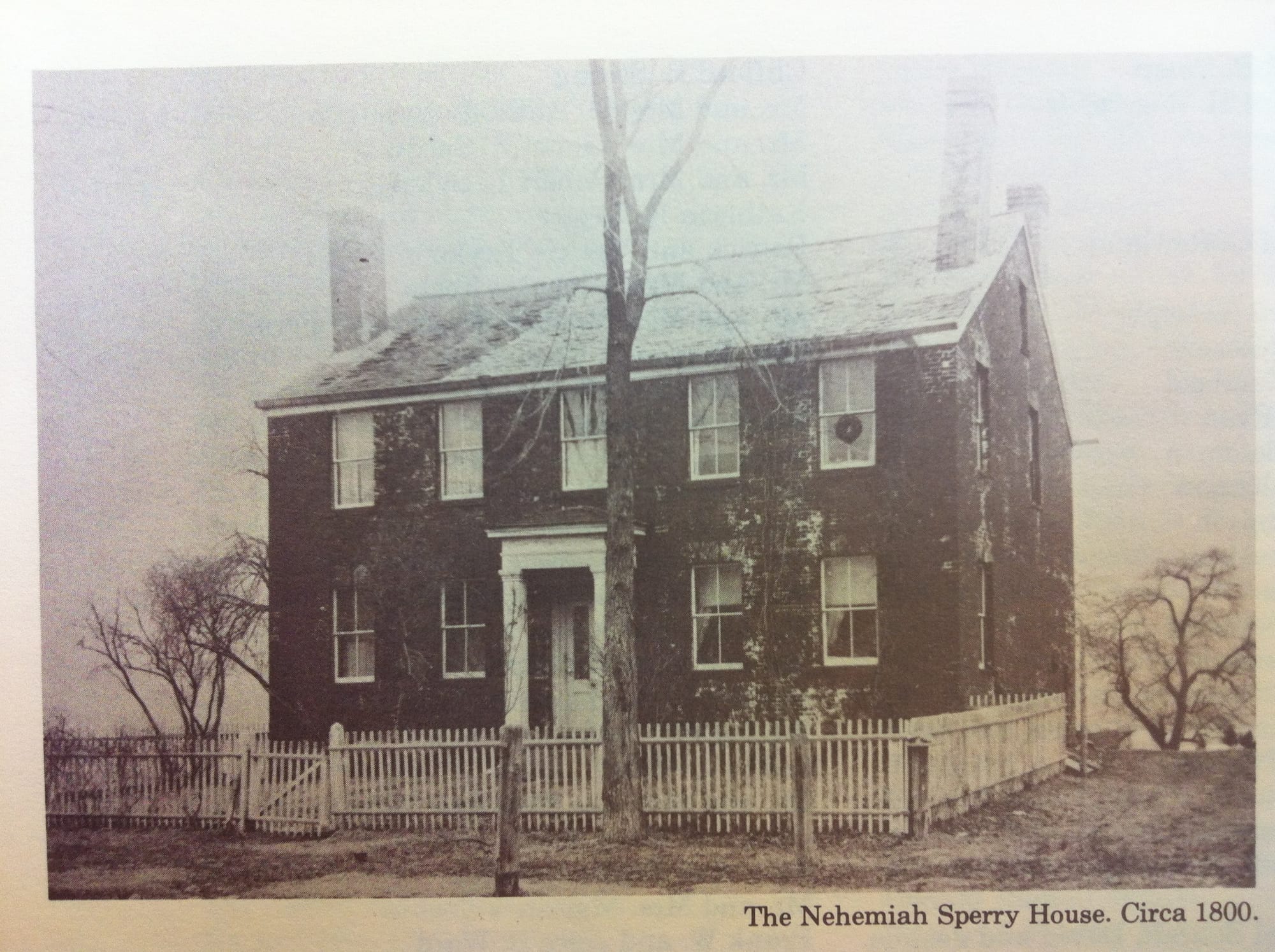
We've mentioned this house before, when Nehemiah Sperry himself comments on it as he passes by during his carriage ride to visit Sperry Falls in 1895. He says, “That brick house over yonder was built by Albert Sperry, who built the North church, New Haven. Mr. Sperry was an uncle of the late Peck Sperry who was for many years in business on Chapel street, New Haven, firm of Skinner & Sperry... And by the way, this turnpike we are riding over is the old Litchfield turnpike. It was a great highway once.”
Another possibility for the location of this ancient Sperry house is discussed in Simon Donato's writing at the West River Valley website, in a post titled, “King's agents, judges & the Sperrys along the West River” in which Simon describes the location of Ebenezer's house as follows (although it's possible that the “C. Sperry” marked on the 1868 Beers map is actually Calvin Sperry, mentioned above):
In 1730 “Sperry Farms” occupied much of the flats north of present day Bradley Road. In or around that year, Ebenezer Sperry, the great-grandson of Richard Sperry built a house on what is now the Luciani Homestead/Farm. In 1835 that house was added to by Ebenezer Sperry’s great grandson, Charles Sperry, who was still living there as per the map of Woodbridge published in 1868 by F. W. Beers. Eventually the property was sold to Charles and Clara Bond. (As in Bond road).
Around 1920, Ettore and Lena Luciani purchased the land from Mr. Bond’s widow which extended south from Bond road, on both sides of Litchfield Turnpike to present day Lawrence Road and extending west beyond Amity Road, including part of Bradley Highlands. (Present day Emeritus Senior Living). At the heart of this parcel was the Charles Sperry House into which Mr. and Mrs. Luciani settled to farm and raise a family.
When that house was added in 1835, the original house had been built over the basement of the house Ebenezer Sperry had built in the early 1730s, and was likely retained as a root cellar.
At any rate, back in 1779 the group “hurrying down the Litchfield Road” past Bathsheba in her doorway were heading to the defense of New Haven and we have a few accounts that can tell us more about the location of their engagement with the Red Coats. Let's first take a look at a map, drawn by Ezra Stiles (1727-1795) who had become Yale's president just one year earlier.
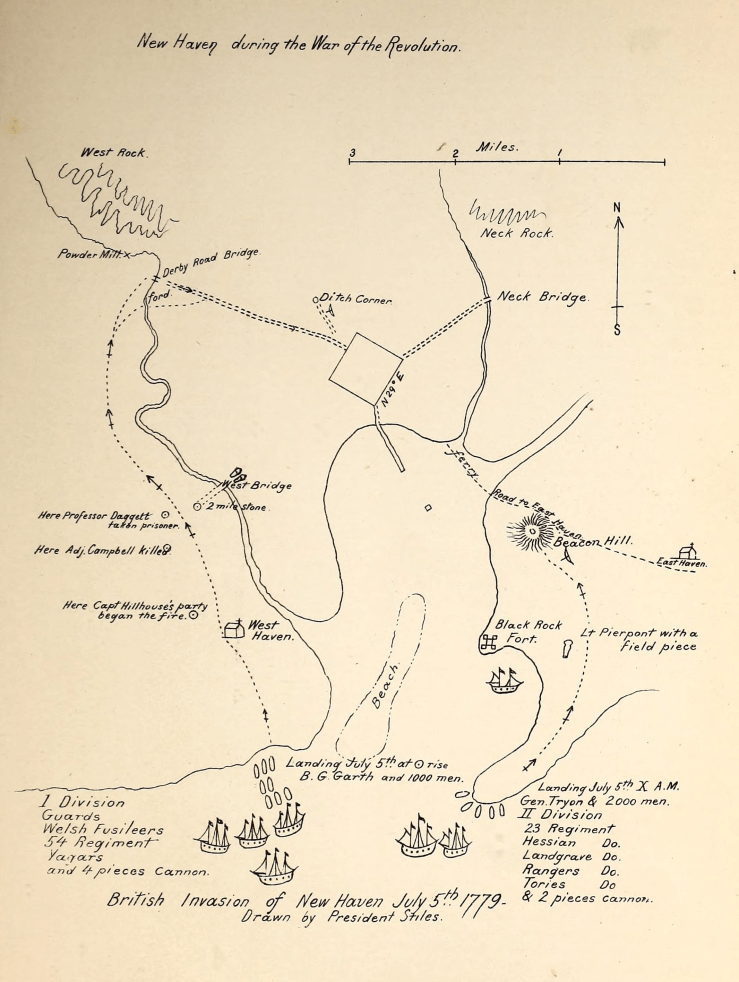
At the top left of the map we see West Rock and vicinity, with the West River winding its way down the left side of the map to its outlet to Long Island Sound where it passes under today's Kimberly Avenue bridge between New Haven and West Haven. But there was no bridge there at this time, so the first crossing the British troops could take as they made their way from landing at Savin Rock and stopping briefly at the current West Haven Green (marked on this map as the location of the Congregational church) was along the King's Highway, the modern Boston Post Road aka Route 1, known in these days as the Milford Road. In this area we see marked the spot where the British Adjutant Campbell was shot (today's intersection of Route 1 and Campbell Avenue, named in his honor) and nearby, where Professor Daggett (the former Yale president) was also taken captive. Along this road, men from the area had taken up positions in the fields and woods and were shooting at the advancing troops.
The British attempted to cross the West River into New Haven at the spot marked West Bridge (near the intersection of today's Route 1 and Ella Grasso Boulevard), and here the defenders of New Haven took a brave stand, driving them back with cannon fire.
Another vignette, this time from the book 'The Invasion of New Haven' by Charles Townsend describes how militia members acted quickly to arm themselves with the firepower necessary to defend New Haven. From page 62:
“Among the brave defenders of New Haven was David Atwater, of Cedar Hill, Hamden, whose wife Elizabeth, was a cousin of the Bassetts of Hamden Plains. These two families had their grants of land north of the town, several hundred acres each, between Quinnipiac and Mill rivers and East Rock, at one time; and the Neck (Fair Haven West), was on the Atwater grant. This David Atwater was a lineal descendant of Joshua Atwater, from County Kent, England, the first treasurer of New Haven Colony under Governor Eaton. On the morning of the invasion this David Atwater took his Dutch horse and whiffletree, and with some of his friends went to an armed vessel which was laying at the wharf, and dismounted one of its six-pound brass guns (an old Spanish piece), and hitching his horse to it, drew it out to West Bridge, and there mounted it with stone and rails from the fence and fired several shots on the approach of the enemy. On account of this and the bridge being taken up, the enemy decided to cross the West river higher up on the Derby road, and the gun was drawn across the fields and fired several times with good effect, and finally abandoned about the Ditch Corner after having been spiked.”
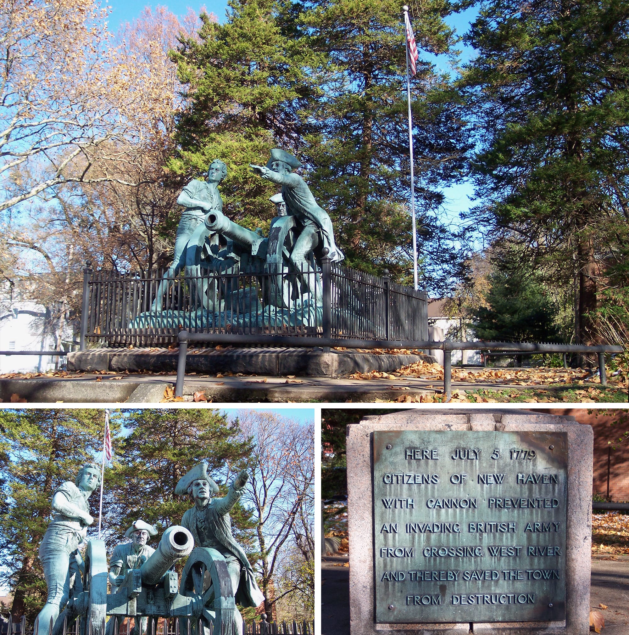
In 1910, a sculpture known as the Defender's Monument was dedicated to the mark the location of this encounter. About a decade later the view of the Defenders as they faced toward West Haven as well as from the vantage point of the invading British troops was depicted in this pair of vintage postcards at a time when much of the surrounding land was more cleared in comparison to the subsequent development of the area.
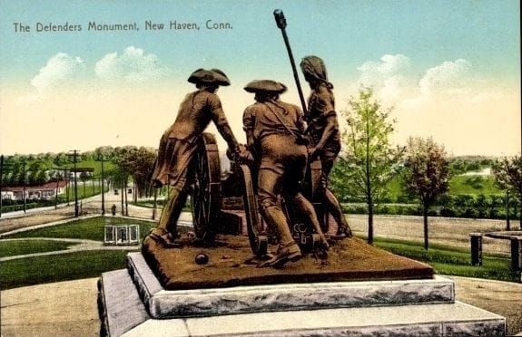
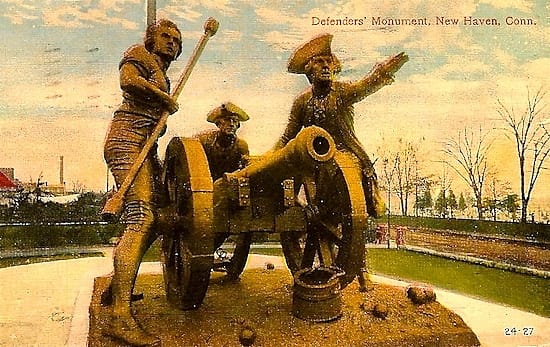
Visiting the site in 2004, the Defenders had taken on a vintage verdigris patina — a grey-green surface layer on copper caused by exposure to the elements over time (a restoration project in 2014 later returned them closer to their original coloring).
Unable to make a crossing at the West Bridge, the British dropped back and proceeded up the road that paralleled the West River to attempt a crossing further north. This brought them to the area on the map labeled the Derby Road Bridge, near the Powder Mill close to West Rock. And this is the likely spot where the men from Woodbridge and Bethany would have engaged the British.
Another vignette appears to pick up the action in Westville. Gideon Hotchkiss (1716-1807) lived in the area of the present day Town of Prospect — up the old Litchfield road from Bethany. His mother Elizabeth was a Sperry, granddaughter of Richard and Dennis Sperry through their son John and his wife Elizabeth Post. Gideon and his wife Anna Brockett (1716-1762) had at least two daughters and eight sons, five of whom served during the Revolution. Gideon was a Lieutenant and then a Captain during the French & Indian War from 1758 to 1759 and was an officer in the militia in 1779 when he led his men to New Haven to defend against the British attack. According to an article in the Connecticut Magazine in 1907;
“When Gideon Hotchkiss heard of the attack on New Haven, July 5, 1779, he was working on his farm. Like Putnam, he mounted his horse in the field, and with a hired boy galloped to the Elm City. He encountered the enemy at Westville, where there was a ford. Arriving at the scene of battle, he dismounted and was about to send the boy home with the steed. Just then a shell struck the boy and killed him instantly. There was no time to show sorrow or sentiment. The old soldier picked up the body and laid it in a concealed place beside the road. Fastening the reins to the saddle, he started the horse back to the farm, and remained to take part in the fray!”
This story is recounted on page 7 of a booklet published in 1976 by the Prospect Bicentennial Commission that examined available research “regarding men who lived in Prospect, and whose names should be remembered for their part in the War of the Revolution.” The booklet noted that shortly after that time the territory was known as Columbia Parish, prior to its incorporation as a Town in 1827. In its entry for Gideon Hotchkiss, the booklet also states:
“Confirmation for this story is given by the fact that Aaron Russell, age 13, whose brothers Riverius and Elmore married granddaughters of Capt. Gideon, is listed among those killed in the attack.”
Another vignette from the book 'The Invasion of New Haven' by Charles Townsend further describes the actions men from Woodbridge and Bethany took on the day of the British attack. From page 62:
“The citizens of the towns of Woodbridge and Bethany seem to have been exceedingly patriotic , but none more so than the families of Sperry of Woodbridge. Mr. Simeon Sperry was grandfather of two of our most honored citizens , ex-Mayor Sperry and the Hon. N. D. Sperry...
Simeon Sperry was descended from Richard Sperry, of the New Haven Colony, whose grant of land was at or near Hatchet harbor and the Judge's Cave on West Rock, and who was made famous in Colonial history for supplying food to the Regicides, Goffe and Whalley. The pioneer Mr. Richard Sperry, resided in the famous old moated manor house in Woodbridge, which was approached in colonial times by a long causeway leading across his estate from the river. On these estates is the celebrated "Ravine" noted for its former woolen manufactories successfully conducted by the Sperrys, and forming a part of one of the wildest and most romantic bits of scenery in New England. On the morning of the invasion Mr. Sperry, with his neighbors, the Lines', Perkins' and Merwins', shouldered their muskets and marched to Allingtown, and there joined Captain Hillhouse's and ex-President Daggett's companies in disputing the enemy's advance into town, and it was this detachment, tradition informs us, that saved the powder mills and captured a large body of the enemy, mostly Hessians. The father of these gentlemen also assisted in erecting the earthworks on Beacon hill, then called Fort Treadwell and afterwards Fort Wooster, after the lamented Major General Wooster, killed by the British at Danbury.”
This area of engagement is also commented on by Ezra Stiles in an account quoted in the Roger Sherman House website's story 'New Haven during the War of the Revolution':
“The northern militia and those from Darby by this time crowded in and pressed on all side – and some behaved with amazing intrepidity. One captain drew up and threw himself and his whole company directly before the enemy’s column and gave and received the fire… The battle became very severe and bloody for a short time, when a number was killed on both sides.
Gen. Tryon reported that Garth’s men were ‘under a continuous fire,’ but the American militia was outgunned and fought a fighting retreat to the northwest corner of New Haven, where Garth finally entered the town at about 1:00 P.M., ‘not without opposition, loss, and fatigue,’ as Tryon recorded.”
George Hare Ford aptly sums up his remembrances of the defenders of New Haven on pg. 38 of the 1911 publication, Revolutionary Characters of New Haven:
The actors on the scene we have contemplated have gone, but the spirit that animated them to battle for their liberties and their homes is the same that has inspired men to heroic deeds since the dawn of civilization.